TECCesiumMap est un composant qui vous permet d'utiliser Cesium dans vos développements Delphi, il n'est pour l'instant disponible que pour la VCL (Windows)
Internet Explorer 11 est le minimum requis pour utiliser Cesium, TECCesiumMap ne fonctionne pas sous XP !
40
Ce composant est intégré dans la suite TECMap
110Installation
Par défaut TECCesiumMap utilise les serveurs de cesiumjs.org, mais pour la mise en production de vos développements je vous conseille fortement d'installer cesium sur votre propre serveur Web.
Téléchargez la dernière archive de Cesium puis dezippez la simplement sur votre serveur.
TECesiumMap dispose de la propriété WebServer qu'il vous suffit de renseigner avec le répertoire racine de votre installation.
Utilisez CreateRuntimeCesiumMap pour une creation dynamique
39cesium := CreateRuntimeCesiumMap(self,panel1);
Vous devez obtenir
une clef pour utiliser l'api de Cesium,
branchez-vous sur l'événement OnInitialize pour
connecter votre Token.
Vous devez aussi placer le fichier cesium-app.html sur
votre serveur.
...
procedure TForm.doInitialize(Sender: TObject);
begin
TECCesiumMap(sender).WebServer := 'http://www.your_serveur.com/cesium-app.html';
TECCesiumMap(sender).IonAccessToken := 'your cesium ion token';
end;
TCesiumControl
La structure est la même que pour TECNativeMap, les éléments fonctionnent de la même manière et vous retrouvez la notions de groupes, la géolocalisation et le calcul des routes sont identiques
Ce composant non visuel est celui qui manipule vraiment Cesium, TECCesiumMap est le composant visuel que vous installez sur vos formes et qui utilise TCesiumControl
111
function Add(const shape: TNativeShape; const Lat, Lng: double; const GroupName: string = ''): TECCesiumShape;
function AddRoute(const routePath: TECroutepath; const GroupName: string = ''): TECCesiumShapeLine;
function AddPOI(const Lat, Lng: double; const GroupName: string = '') : TECCesiumShapePOI;
function AddPOIText(const Lat,Lng:Double;const Text:string='';const GroupName:string=''): TECCesiumShapePOI;
function AddMarker(const Lat, Lng: double; const GroupName: string = '') : TECCesiumShapeMarker;
function AddLine(const Lat, Lng: double; const GroupName: string = '') : TECCesiumShapeLine;
function AddPolygone(const Lat, Lng: double; const GroupName: string = '') : TECCesiumShapePolygone;
function AddInfoWindow(const X,Y: double; const GroupName: string = '') : TECCesiumShapeInfoWindow;
Contrairement à TECNativeMap dans TECCesiumControl vous indiquez des coordonnées écran pour positionner votre fenêtre d'information
41procedure Remove(const shape: TECCesiumShape);
procedure Clear
procedure BeginUpdate
procedure EndUpdate
procedure SaveToFile(const Filename: string);
procedure LoadFromFile(const Filename: string)
procedure setCenter(const Lat, Lng: double);
procedure fitBounds(const NELat, NELng, SWLat, SWLng: double);
procedure fitBoundsRadius(const dLat, dLng, dRadiusKm: double);
procedure FlyTo(const Lat, Lng, alt: double);
procedure Jumpto(const Lat, Lng, alt: double);
procedure LookAt(const Lat, Lng, alt: double);
procedure GECamera(const Lat, Lng, alt, Tilt, Heading, roll: double);
procedure Javascript(const js:string);
function GetRoutePathByAdress(const StartAdress, EndAdress: string; const routeType: TMQRouteTyp = rtFastest; const params: string = ''): TECroutepath;
function GetRoutePathFrom(const dLatLngs: array of double; const routeType: TMQRouteType = rtFastest; const params: string = ''): TECroutepath;
function GetASyncRoutePathByAdress(const StartAdress, EndAdress: string; const routeType: TMQRouteTyp = rtFastest; const params: string = ''): TECroutepath;
function GetASyncRoutePathFrom(const dLatLngs: array of double; const routeType: TMQRouteType = rtFastest; const params: string = ''): TECroutepath;
property Address: string
property MouseLatLng: TLatLng
property MouseAlt: double
property ScreenShot: TBitmap
property ClickX : integer read FClickX;
property ClickY : integer read FClickY;
property MouseX : integer read FMouseX;
property MouseY : integer read FMouseY;
property Shapes: TECCesiumShapes read FShapes;
property HintInfoWindow : TECCesiumShapeInfoWindow read getHintInfoWindow;
property Group[value: string]: TECCesiumShapes read getShapesGroup;
property Groups:TECGroupShapesList read getShapesGroups;
property toKml: string read getToKml write setToKml;
property toGpx: string read getToGPX write setToGpx;
property toTxt: string read getToTxt write setToTxt;
property toGeoJSon: string read getToGeoJSon write setToGeoJSon;
property Url: string read getUrl write setUrl;
property WebServer : string read FWebServeur write setWebServeur;
property BingKey: string
property Latitude: double ;
property Longitude: double ;
property Altitude: double;
property Zoom: double;
property Draggable;
property TileServer: TTileServer
Les serveurs suivant sont disponibles :
- tsOpenMapQuest
- tsOSM
- tsOpenCycleMap
- tsArcGisWorldTopoMap
- tsArcGisWorldStreetMap
- tsArcGisWorldImagery
- tsBingRoad
- tsBingAerial
- tsBingAerialLabels
Il est conseillé de remplir la propriété BingKey avec votre clef Bing pour utiliser les tuiles de Bing Maps ( tsBingRoad, tsBingAerial, tsBingAerialLabels )
map.BingKey :=
YOUR_BING_KEY
map.TileServer := tsBingRoad;
property Terrain: boolean;
property SceneMode: TCesiumMode;
Sélectionne le type d'affichage, par défaut 3D
- cm2D
- cmColombus
- cm3D
Événements
property OnMapClick: TOnMapLatLng
property OnMapRightClick: TOnMapLatLng
property OnMapMove: TOnMapLatLng
property OnMapMouseMove: TOnMapLatLng
property OnMapMouseUp: TOnMapLatLng
property OnMapMouseDown: TOnMapLatLng
property OnShapeMove: TOnShapeMove
property OnShapeDrag: TOnShapeMove
property OnShapeDragEnd: TNotifyEvent
property OnShapeMouseOver: TOnShapeMouseEvent
property OnShapeMouseOut: TOnShapeMouseEvent
property OnShapeMouseDown: TOnShapeMouseEvent
property OnShapeMouseup: TOnShapeMouseEvent
property OnShapeClick: TOnShapeMouseEvent
property OnShapeRightClick: TOnShapeMouseEvent
property OnShapePathChange: TNotifyEvent
property OnCloseInfoWindow: TOnCloseInfoWindow
property OnRoutePath: TOnRoutePath
property OnLoad: TOnLoadGroup
property OnLoadShapes: TOnLoadShapes
property OnUrl: TOnUrl
property OnCZML: TOnCZML
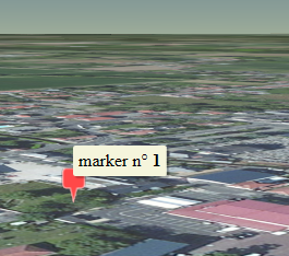
TECCesiumShapeMarker
i :=
cmap.Shapes.Markers.Add(lat,lng) ;
// hint accept html
cmap.Shapes.Markers[i].Hint := 'marker n°
<b>'+inttostr(i)+'</b>';
uses
uecCesiumShape;
var marker :
TECCesiumShapeMarker;
// use the shortcut to create the
marker
marker := cmap.AddMarker(Lat,lng);
// you can find index with
marker.IndexOf
//
cmap.shapes.markers[marker.indexOf]
// add a text
marker.Description := 'Text';
// adapt width
marker.Width := 70;
// change color
marker.Color := clOlive;
// use the
shortcut to create the marker
marker := cmap.AddMarker(Lat,lng);
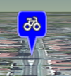
// use maki icon
marker.Description := 'maki:bicycle';
marker.Width := 64;
marker.Color := clBlue;
// set draggable
marker.Draggable := true;
// use the
shortcut to create the marker
marker := cmap.AddMarker(Lat,lng);
// use png file
marker.Filename := 'http://www.helpandweb.com/cake_32.png';;

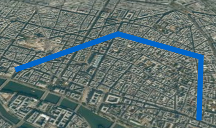
TECCesiumShapeLine
var
line : TECCesiumShapeLine;
// create line and add first point
Latitude, Longitude
line := cmap.AddLine(48.8594069779731,2.34283447265625) ;
// better for
optimisation
line.BeginUpdate;
// change color
line.Color := clHotLight;
// change size
line.Weight := 10;
// add other points
line.Add(48.8638113489879,2.35519409179688);
line.Add(48.8608751447095,2.36532211303711);
line.Add(48.8543245298006,2.36360549926758);
// update
line.EndUpdate;
// zoom to line
line.fitBounds;
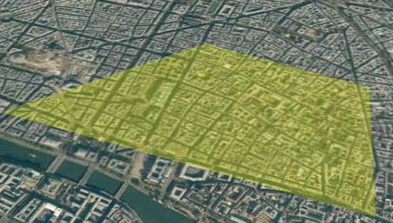
TECCesiumShapePolygone
var
polygone : TECCesiumShapePolygone;
// create polygone and add first
point Latitude, Longitude
polygone := cmap.AddPolygone(48.8594069779731,2.34283447265625) ;
// better for
optimisation
polygone.BeginUpdate;
// change color
polygone.fillColor := clYellow;
// change opacity
polygone.fillOpacity := 30;
// add other points
polygone.Add(48.8638113489879,2.35519409179688);
polygone.Add(48.8608751447095,2.36532211303711);
polygone.Add(48.8543245298006,2.36360549926758);
// update
polygone.EndUpdate;
// zoom to polygone
polygone.fitBounds;
TECCesiumShapePOI
Contrairement à TECNativeMap seul les types poiEllipse et poiText sont supportés pour l'instant
42var
Poi : TECCesiumShapePOI;
Poi := cmap.AddPOI(lat,lng) ;
Poi.BorderSize := 2;
Poi.Color := clBlue;
Poi.BorderColor := clWhite;
// 16 pixels
// for meters use Poi.POIUnit :=
puMeter;
Poi.Width := 16;

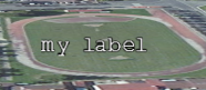
var
Poi : TECCesiumShapePOI;
Poi := cmap.AddPOIText(lat,lng,'my
label') ;
// use description for change
text
//Poi.Description := 'my new
label';
// font
Poi.CssFont := '14pt
monospace';
// color
Poi.Color := clWhite;
Material
Vous pouvez utiliser la propriété material pour par exemple incruster une image dans un polygone.
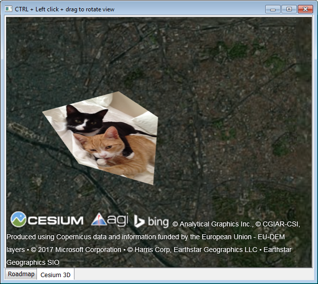
Vous pouvez directement utiliser du javascript pour définir un material plus complexe.
'image : "'+UrlImageToDataUri('d:\alert-weather.png')+'",'+
'transparent:true })';
TECCesiumShapeInfoWindow
Contrairement à TECNativeMap la position des InfoWindows est indiquée en coordonnées écran, vous pouvez utiliser du html pour votre contenu et utiliser CSS pour styler vos InfoWindows
var
wn:TECCesiumShapeInfoWindow;
Wn := cmap.AddInfoWindow(10,10)
;
Wn.content := 'You can enter
<b>html</b> content <br>text and
<i>image</i> <img
src="http://www.helpandweb.com/cake_32.png"/>';
;
// you can style with
css
Wn.Style := 'here css';
// use color for color
background
Wn.Color := clWhite;
Wn.CloseButton := true;
L'événement OnCloseInfoWindow du composant TECCEsiumMap est déclenché lorsque l'on ferme par la croix et l'InfoWindow qui vient d'être fermée est récupérée.
Si votre fenêtre contient un lien, le click déclenche l'événement OnUrl
8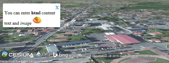
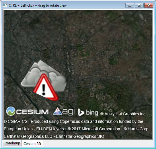
TECCesiumShapeModel
Cette classe gère les modèles 3D, Cesium utilise le format glTF, un convertisseur COLLADA -> gLTF est proposé
var
model : TECCesiumShapeModel;
// you can use url or local
filename for your .gltf
model := cmap.addModel(lat,lng,'http://cesiumjs.org/Cesium/Apps/SampleData/models/CesiumGround/Cesium_Ground.gltf')
;
// Values greater than 1.0 increase
the size of the model
// while values less than 1.0
decrease it.
model.Scale := 2.0;
// specifying the approximate
minimum pixel size of the model regardless of
zoom.
// This can be used to ensure that
a model is visible even when the viewer zooms
out
model.MinimumPixelSize := 64;
//
Orientation(heading,pitch,roll)
model.Orientation(90,model.Pitch,model.Roll);

CZML
CZML est l'équivalent en plus puissant du langage KML utilisé par google earth
procedure LoadCZML(const CZML:string;const idCZML:string="";const Options:string='';const Promise:string='');
Pour les options voir //cesiumjs.org/Cesium/Build/Documentation/CzmlDataSource.html (Cesium.CzmlDataSource.load(czml, options))
Promise permet d'executer du javascript quand le script czml est terminé, LoadAndZoomToCZML l'utilise.
var promise:string;
begin
promise := 'viewer.zoomTo(datasourceczml);'
LoadCZML(CZML,idCZML,Options,promise);
end;
Lorsque le script est terminé l'évènement OnCZML de votre composant est déclenché, il retourne idCZML
procedure LoadAndZoomToCZML(const CZML:string;const idCZML:string='';const Options:string='');
'"name" : "CZML Point",' +
'"version" : "1.0"'+
'}, {'+
'"id" : "toto",'+
'"name": "pointx",'+
'"position" : {"cartographicDegrees" : [-111.0, 40.0, 0]'+
'},'+
'"point": {'+
' "color": {"rgba": [255, 255, 255, 255] },'+
' "outlineColor": {"rgba": [255, 0, 0, 255]'+
' },'+
' "outlineWidth" : 4,'+
' "pixelSize": 20'+
' }'+
'}]';
Cesium.LoadAndZoomToCZML(czml,'add_point');