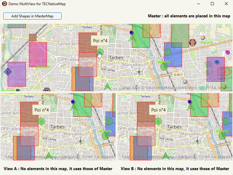
you can connect several TECNativeMaps to your main map and obtain as many different views.
The views are independent of each other, the data are not duplicated they only exist in the main map..
Any modification to the data in one of the views is immediately reflected in all the maps, adding elements in one of the secondary views is actually integrated into the main view.
procedure TNativeMapControl.AddView(const view:TNativeMapControl);
procedure TNativeMapControl.ReleaseView(const view:TNativeMapControl);
procedure TNativeMapControl.ReleaseAllView;
property TNativeMapControl.ViewCount : integer;
property TNativeMapControl.Views[index:integer] : TNativeMapControl
property TNativeMapControl.OnAddShapeToView : TOnAddShapeToView
Tune in to this event if you want to filter the items displayed in the view
Example, we want to see that elements of type TECShapePOI star shaped
Map.addView(ViewA);
// add filter on ViewA
ViewA.OnAddShapeToView := doOnAddShapeToView;
...
procedure TForm.doOnAddShapeToView(sender : TObject; const Shape:TECShape;var cancel:boolean) ;
begin
// sender is the view, cast for use TECNativeMap(sender);
if Shape is TECShapePOI then
cancel := not (TECShapePOI(shape).POIShape = poiStar)
else
cancel := true;
end;
begin
MasterMap.AddView(ViewAMap);
MasterMap.AddView(ViewBMap);
MasterMap.Shapes.Pois.Labels.Visible := true;
MasterMap.Shapes.Pois.Labels.Align := laCenter;
MasterMap.Shapes.Pois.Labels.Margin := 0;
MasterMap.Shapes.Pois.Labels.Style := lsTransparent;
end;
procedure TFormMultiView.AddMasterPoisClick(Sender: TObject);
var
x, y,r: integer;
P: TECShapePOI;
M: TECShapeMarker;
Poly:TECShapePolygone;
SouthWest, NorthEast: TLatLng;
Lat, Lng,
dx, dy: double;
begin
// add shape only in MasterMap
MasterMap.BeginUpdate;
dy := (MasterMap.NorthEastLatitude - MasterMap.SouthWestLatitude) / 2;
dx := (MasterMap.NorthEastLongitude - MasterMap.SouthWestlongitude) / 2;
for y := 0 to 5 do
begin
for x := 0 to 5 do
begin
Lat := MasterMap.latitude - dy + (random(round(dy*2 * 1000)) / 1000);
Lng := MasterMap.longitude - dx + (random(round(dx*2 * 1000)) / 1000);
r := random(3);
// add Marker or Polygon or Poi
if r=0 then
begin
M := MasterMap.AddMarker(lat,lng);
M.Hint := 'Marker n°'+inttostr(M.IndexOf);
M.Draggable := true;
M.Color := GetrandomColor;
end
else
if r=1 then
begin
SouthWest.Lat := lat;
SouthWest.Lng := lng;
NorthEast.Lat := lat+0.005;
NorthEast.Lng := lng+0.005;
poly := MasterMap.AddPolygone(SouthWest,NorthEast);
poly.FillColor := GetrandomColor;
end
else
begin
P := MasterMap.AddPoi(Lat,Lng);
P.width := 32;
P.height := 32;
P.hint := 'Poi n°' + inttostr(P.IndexOf);
P.Description := inttostr(P.indexof);
P.Draggable := true;
P.FillOpacity := 10+random(90);
P.BorderSize := 2;
case random(13) of
0:
P.POIShape := poiEllipse;
1:
P.POIShape := poiStar;
2:
P.POIShape := poiTriangle;
4:
P.POIShape := poiDiamond;
5:
P.POIShape := poiHexagon;
6:
P.POIShape := poiArrow;
7:
P.POIShape := poiArrowHead;
8:
P.POIShape := poiCross;
9:
P.POIShape := poiDiagCross;
10:
begin
P.POIShape := poiDirectionSign;
P.width := 64;
end;
12:
P.POIShape := poiRect;
11:
begin
// now draw, only text label
P.POIShape := poiNone;
P.Description := 'Poi n°' + inttostr(P.IndexOf);
end;
end;
P.Color := GetHashColor(lowercase(copy(psToStr(P.POIShape), 4)));
end;
end;
end;
MasterMap.EndUpdate;
end;
procedure TFormMultiView.FormResize(Sender: TObject);
begin
pnViews.Height := ClientHeight div 2;
pnRight.Width := ClientWidth div 2;
end;