The roads are managed by the list
Routes Type
TECMapRoutes
TECMapRoutes
This list has the following methods and properties
:
function
Add(const sName:string;const
dStartLatitude,dStartLongitude,dEndLatitude,dEndLongitude:double;
const OptimizeWaypoints:boolean=false;const
WayPoints:TLatLngList=nil):integer;
Adding a road, returns the index of the road in
the list
Raises the event OnRouteChange on
success otherwise OnRouteError
Name name of your road, can be
empty
dStartLatitude,dStartLongitude
starting point of the road
dEndLatitude, dEndLongitude
endpoint of the road
OptimizeWayPoints force the
calculation of the most direct route by reorganizing
your crossings (has no action under
CloudMade)
WayPoints
list type
TLatLngList of
crossings.
Pass nil if you do not specify a particular
crossing points
35
function
AddByAdr(const
sName,sStartAdress,sEndAdress:string;
const OptimizeWaypoints:boolean=false;const
WayPoints:TLatLngList=nil):integer;
Adding a road, returns the index of the road in
the list
Raises the event OnRouteChange on
success otherwise OnRouteError
Name name of your road, can be
empty
sStartAdress Address of the
starting point of the road
sEndAdress Address endpoint of
the road
OptimizeWayPoints force the
calculation of the most direct route by reorganizing
your crossings (has no action under
CloudMade)
WayPoints
list type
TLatLngList of
crossings.
Pass nil if you do not specify a particular
crossing points
36
AddByAdr is not available
CloudMade
15
procedure
Clear;
Clears all routes
function
Count:integer;
Returns the number of routes
procedure
Delete(index:integer);
Clears the road index Index
procedure
Undo(index:integer);
Cancels the change of direction made the mouse on the
road index
Index
You can undo changes in the last ten trip.
Not available CloudMade
16
function
Ready:boolean;
Indicates whether you can add a route, you can not do
when a road is about to be calculated.
property
TravelMode:
TDirectionsTravelMode
Property read / write
which can select the type of route you want
property
Distance :
longint;
Read-only property
that returns the length of all roads in
meters
property
Duration :
longint;
Read-only property
that returns the time it takes, in
seconds, to make journeys.
Not available CloudMade
17
property
avoidHighways :
boolean;
Property read /
written offering the choice of avoiding
motorways or not
property
avoidTolls :
boolean;
Property read /
written offering the choice whether to avoid
toll roads
property
Color : TColor;
Property read /
written offering the choice to set the color
of the road
property
Draggable :
boolean;
Property
read /
written that allows the mouse to change the
route of the road.
With the API CloudMade you can not change the
points of departure / arrival and
passages
11
property
Opacity : double;
Property read /
written, which adjusts the percentage of
opacity of the color of the road
property
Weight : integer;
Property read /
written which sets the size of the Roadway
property
ZIndex : integer;
Property read /
written, attribute a priority index for the
display of the road, a road with a zIndex higher will
be displayed on top of that with a lower zIndex
property
MarkerOptions :
TECMapMarker;
property
Route[index:integer]:TECMapRoute;
default;
Table for road access is the default property so you
can access it directly by map.Routes
[index] instead of map.Routes.Route
[index]
property
ToKml : string;
Read-only property
that returns a string in
kml format containing the list of roads
property
ToTxt : string;
Property
read / write
which gives access to the route list in text
format.
In writing there is an addition and not a
replacement, if you do not want to keep the old
values before making a Clear
adding
37
wp := TLatLngList.create(nil);
try
wp.add(43.2237336276672,0.0462043685729441);
map.Routes.Color := clGreen;
id := map.Routes.Add('my first
route',
43.2328643,0.074120799999946,
43.0946324606031,-0.0254427986328665,true,
wp);
finally
wp.free;
end;
Events
OnRouteChange(sender: Tobject;const
idRoute:integer;const NewRoute:boolean)
idRoute is the index of the road
in the list Routes
NewRoute equal
True it is an addition to road,
False if a rerouting
OnRouteError(sender:
Tobject;const idRoute:integer;const
sError:string)
idRoute is the index of the road
in the list Routes
sError explanation of the
error
TECMapRoute
TECMapRoute is the class that handles a route, it
gives you access to methods and properties :
function
getLatLngFromMeter(const
SensStartEnd:boolean;const
lMeter:longint;
var
dLatitude,dLongitude:double;
var
idPoint:integer;
var
heading:integer;var bEnd:boolean):boolean;
Calculates the latitude and longitude of a point
on the road according to its distance in meters,
returns True if we found a point
SensStartEnd meaning of course,
true for start -> finish
lMeter the distance in meters
dLatitude,dLongitude type
variables double who will receive
the latitude and longitude
idPoint a variable that will
contain the index Path where is the
point, the calculation returns an approximation,
since your drive does not contain all the real
points
Heading a variable to hold the
angle of the point from the north ( 0 to 360°)
bEnd indicates whether it has
exceeded or reaches the end of the road (or early
depending on the direction)
procedure
fitBounds
Adjusts the zoom of the map to display all of the
road
procedure
Update;
Redefined the road to reflect changes made to any of
the properties
procedure
OptimizeWaypoints;
Rearranges the way points for their order to be
optimal
Not available CloudMade
18
procedure
updateOptions;
Redraw the road to reflect properties Color,
Opacity, and Weight
Draggable
Read-only property
that returns the length of the road in
meters
property
Duration :
longint;
Read-only property
that returns the time it takes in
seconds for the journey.
Not available CloudMade
19
property
Path :
TECMapRoutePath;
List Type TECMapRoutePath containing the road
constituent points
property
WayPoints :
TLatLngList;
List of crossings
property
Copyright :
string;
The possible copyright holder for this route
property
StartAdress :
string;
Address of starting point, read-only
Not available CloudMade
20
property
StartLatitude :
double;
Property read / write
from the point of Latitude
property
StartLongitude :
double;
Property read / write
Longitude of starting point
property
EndAdress :
string;
Address of the destination point, readonly
Not available CloudMade
21
property
EndLatitude :
double;
Property read / write
from the point of arrival Latitude
property
endLongitude :
double;
Property read / write
from the point of arrival Longitude
property
Name : string;
Read-only property
that returns the name of the road telqu'il has been
indicated to the creation
property
Id : integer;
Read-only property
that returns the index of the road in the list
Routes
property
NorthEastLatitude :
double;
Read-only property
that returns the latitude of the north-east corner of
the area surrounding the entire road
property
NorthEastLongitude :
double;
Read-only property
that returns the longitude of the northeast corner of
the area surrounding the entire road
property
SouthWestLatitude :
double;
Read-only property
that returns the latitude of the southwest corner of
the area surrounding the entire road
property
SouthWestLongitude :
double;
Read-only property
that returns the longitude of the southwest corner of
the area surrounding the entire road
property
TravelMode:
TDirectionsTravelMode
Property read / write
which can select the type of route you want
property
avoidHighways :
boolean;
Property read /
written offering the choice of avoiding
motorways or not
property
avoidTolls :
boolean;
Property read /
written offering the choice whether to avoid
toll roads
property
Color : TColor;
Property read /
written offering the choice to set the color
of the road
property
Draggable :
boolean;
Property
read /
written that allows the mouse to change the
route of the road.
With the API CloudMade you can not change the
points of departure / arrival and
passages
12
property
Opacity : double;
Property read /
written, which adjusts the percentage of
opacity of the color of the road
property
Weight : integer;
Property read /
written which sets the size of the Roadway
property
ZIndex : integer;
Property read /
written, attribute a priority index for the
display of the road, a road with a zIndex higher will
be displayed on top of that with a lower zIndex
property
MarkerOptions :
TECMapMarker;
Property that allows you to manipulate the markers of
departure and arrival by changing the icon for
instance, unfortunately we can not yet
differentiate.
Not available CloudMade
22
property
Tag :integer;
Property read /
written, you can use it freely for whatever
you want stoker
property
ToKml : string;
Read-only property
that returns a string in
kml format contains the route
property
ToTxt : string;
Property
read / write
which gives access to the road in a text
format.
In writing there is an addition and not a
replacement, if you do not want to keep the old
values \u200b\u200bbefore making a
Clear adding
39
TECMapRoutePath
List of points on the route, it gives you access to
methods and properties
function
Distance:integer;
Distance in meters
function
Duration:integer;
Duration in seconds
function
Count:integer;
Returns the number of points constituting the
road
function
IndexOfLatLng(const
dLatitude,dLongitude:double):integer;
Returns the index of a point we pass the latitude
and longitude, -1 if no item
property
Point[index:integer]:TECMapRoutePathPoint;
default;
Table for access points is the default property
so you can access it directly by
map.Routes [idroute]. Path
[idPoint] instead of map.Routes
[idroute]. Path.Point [idPoint]
TECMapRoutePathPoint
Class manager point of the road, it gives you
access to properties
property
Altitude : double;
Read-only property
that returns the height in meters from the point
property
Instructions :
string;
Read-only property
that returns the instructions in
HTML, associated with the point
property
Latitude :
double;
Read-only property
that returns the latitude of the point
property
Longitude :
double;
Read-only property
that returns the longitude of
property
Distance :
longint;
Read-only property
that returns the distance in meters
property
Text :
string;
Read-only property
that returns the instructions in text format
AddPolylineFromRoute
TECMap has a feature that allows you to add a
polyline from the index of a
road
map.apiVersion := '3.7';
Cela peut-être utile pour "figer"
une route, en effet lors de la sauvergarde d'une
route seul les points de départ et d'arrivée sont
sauvés, lors de la lecture un recalcul de la route
sera effectué.
Polylines can calculate batch
altitude points while for the roads it must be
done step by step, DemoRoute uses
AddPolylineFromRoute to calculate the
elevation.
Utility functions
function
TECMap.GetRoutePathFrom(const
dLatLngs: array of double;const params): TECMapRoutePath;
procedure
TECMap.GetASyncRoutePathFrom(const
dLatLngs: array of double;const params:
string);
function
TECMap.GetRoutePathByAdress(const
StartAdress, EndAdress: string;const params:
string): TECMapRoutePath;
procedure
TECMap.GetAsyncRoutePathByAdress(const
StartAdress, EndAdress: string;const params:
string);
These four routines to get a road without made
of path information, you have two asynchronous
procedures that will run in the background and
raise the OnRoutePath event when the data are
available.
If you do not release the TECMapRoutePath
obtained, it will be automatically during the
destruction of TECMap
40
You can create a polyline from a
TECMapRoutePath
routePath :=
map.GetRoutePathByAdress('Tarbes','Aureilhan|Lourdes');
if
routePath<>nil then
begin
id :=
map.polylines.addFromRoutePath(routePath);
map.polylines[id].fitBounds;
routePath.free;
end;
function
TECMap.
DistanceFrom(const
LatStart, LngStart,LatEnd, LngEnd: double):
double;
Returns the distance in KM between two
geographical points, uses the haversine
formula
function
TECMap.
DistanceRouteByAdress(const
StartAdress, EndAdress: string;const params:
string= ''): double;
Returns the distance in KM between two
addresses passing by road
function
TECMap.
DistanceRouteFrom(const
dLatLngs: array of double;const params: string =
''): double;
Returns the distance in KM between two
geographic points through the road
function
TECMap.
AddRouteByAdress(const
Adresses:TStrings):integer;
Adds a route, Adresses
contains the addresses of passages.
dKm := map.DistanceRouteByAdress('Tarbes','Aureilhan|Lourdes');
Adresses := TStringList.create;
try
Adresses.add('Tarbes');
Adresses.add('Aureilhan');
Adresses.add('Séméac');
Adresses.add('Lourdes');
map.AddRouteByAdress(Adresses);
finally
Adresses.free;
end;
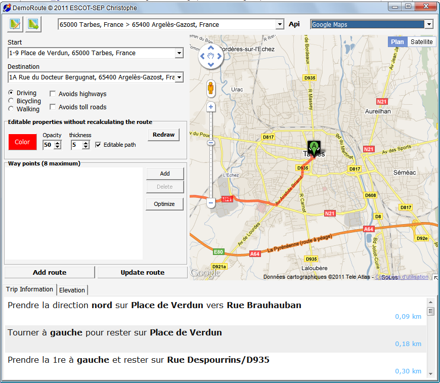
DemoRoute
The program DemoRoute shows you how
to operate the routes
 Fig. 40 DemoRoute -
Instructions
Fig. 40 DemoRoute -
Instructions
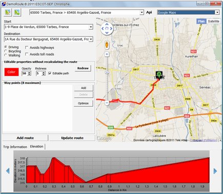 Fig. 41 DemoRoute -
Altitudes
Fig. 41 DemoRoute -
Altitudes